By Chris Martz | November 27, 2019
Millions of Americans have already begun travelling for the Thanksgiving holiday, though many more have yet to depart on their adventure.
Depending upon where you are travelling, there could be some quite hazardous weather to be on the lookout for. Unfortunately, much of the U.S. will see impacts from a large storm system which slammed into the West Coast yesterday morning bringing damaging winds, potentially record-breaking snowfall, and heavy rains.
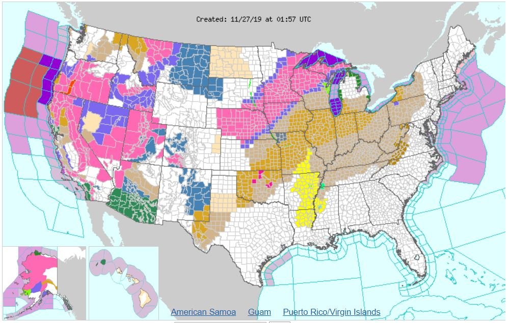
Yesterday, last evening, and early this morning, the Upper Midwest and Great Plains were under Winter Weather Advisories and Winter Storm Warnings as a mid-latitude (extratropical) cyclone swept over the region bringing staggering snowfall totals.
According to the National Weather Service office in Minneapolis, 9.2 inches fell at Minneapolis-Saint Paul International Airport. If this daily total is indeed correct, this would break the old record of 4.9 inches set in 1983. Yesterday’s snowfall total was 2.0 inches, which didn’t break the record of 5.9 inches set in 2001. For the storm total (as of now), Minneapolis has picked up 11.2 inches of snow. To put that into perspective, that’s more snow than Washington, D.C. has seen in a single storm since the Blizzard of 2016.
Denver, Colorado picked up 9.5 inches of snow from this storm: exactly one inch fell on the 25th and 8.5 inches fell yesterday. Neither broke daily records, which were 5.0 inches (1908) and 11.1 inches (1983), respectively.
Boulder, just to the northeast of Denver, picked up a staggering 22.3 inches of snow from this two-day storm. 20.7 inches fell yesterday which obliterated the old daily record of 13.0 inches from 1959. The two-day snow total ranked third largest for Boulder in the entire period of record keeping, which dates back to October 1, 1893.

Our storm system has died down a bit as it moves off towards New England and into Quebec. Some light to moderate snow showers have popped up to the North of Pittsburgh, and heavier rains can be found across upstate New York, with heavier snow across mountainous Maine.
Our pressure gradient has tightened with the passage of this storm system, which is why it has been and will continue to be windy this evening and much of the day tomorrow across the Mid-Atlantic and Northeastern states. (I can confirm it’s windy: I went to pick up dinner at Manhattan Pizza in Purcellville, VA and almost ran over a tipped trash can in the middle of the road; another car almost hit it too – ha ha!)

Meanwhile, another powerful storm is wreaking havoc across the western portion of the United States this evening. Heavy coastal rains have engulfed much of California and our lowlands while the higher elevations, including the Cascade and Sierra Nevada mountains, are getting pounded with snow as moist air is forced to rise over the mountains and precipitate into cold air.
The storm slammed into the West Coast yesterday morning as a very organized structured, powerful Pacific cyclone which had undergone what meteorologists call “explosive cyclogenesis.” (This is what the media calls “Bomb Cyclones.”) Since then, the storm has fallen apart, but the low pressure area still remains.

Because of the snow threat, the National Weather Service has issued Winter Weather Advisories, Winter Storm Watches, Winter Storm Warnings, and yes, our favorite, Blizzard Warnings across the western half of the country.

Before the storm system moves out over the Great Plains, expected snowfall totals are staggering in the ski areas. As much as 30 more inches (in addition to what they already have) will fall in the Sierra Nevadas over the next two days. The mountains of New Mexico, Arizona, Nevada, Utah, Colorado, and Wyoming can expect anywhere from 12 to 50 inches of snow.

From there, the storm will track to the northeast as the low redevelops and strengthens bringing one to two feet of snow across Montana and the Dakotas this weekend.

I’ll have another blog update on this second system on Friday or Saturday, so please stay tuned to my Twitter, Facebook, and Instagram pages for more information. Other than this bit of information, the country looks fairly okay weather-wise for Thanksgiving.
On that note, I hope everyone has a wonderful Thanksgiving. God bless!
Categories: Uncategorized

Leave a comment