Good morning everyone!
As promised, I have another weather update regarding our big storm system which will be producing a blizzard over the Dakotas and Upper Midwest today and some decent interior mountain snow tomorrow through Tuesday across Southern New England.
Our current upper air pattern at 500 millibars (~18,000 feet) shows some interesting features. Our Greenland blocking pattern is beginning to fade away which has allowed a ridge to build in across the Eastern United States with a massive, deep trough over the West Coast. The weakening of the ridge over Greenland is largely the result of the North Atlantic Oscillation (NAO) beginning to shift into it’s positive mode. Another important feature on the map below is where I have labeled “PV” over Northern Canada. That’s a polar vortex feature and it’s locked up over the Arctic meaning that the Arctic Oscillation (AO) is turning positive. With both of these teleconnections going positive, that locks the cold air supply up in the icebox of Canada rather than unleashing it into the Lower 48.
Our upper level low from our surface storm exited the Rockies overnight and is now over the Great Plains. With the area of high pressure to the north of the cut-off low, the wind flow around the high is pulling in some decently, but not significantly cold air.
Additionally, the placement of that ridge will shove our storm system to the east and somewhat to the south allowing the storm to reorganize off the New Jersey coast tomorrow.

Temperatures across the Dakotas and Upper Midwest are not unseasonably cold this morning, most areas are in the mid-to-upper 20s this morning and due to the cloud cover expanding, temperatures won’t budge a whole lot as the day progresses onward.

Our surface low is being fueled off of a lot of rising motion in the troposphere. Tons of moisture from the Gulf of Mexico and the Pacific has been drawn in to the cyclonic circulation over the last day or so and with a lot of surface convergence occurring along the Nebraska-Colorado border, this rising air condensates and forms clouds which has formed heavy precipitation mainly in the form of snow.

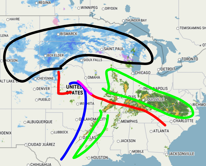
Current radar imagery shows an organized circulation with our storm system. Frontogenesis and sharp temperature gradient across the north quadrant of the storm has fueled heavy bands of snow over the Dakotas, Minnesota, and Wisconsin (black line) with rates of 1-2+ inches of snow per hour. Our cold front (blue line) extends from the low pressure center south into Texas which has sparked some heavy thin rain bands across the Deep South and Mississippi Valley, and the warm front has done the same over the Southern Midwest.
The National Weather Service has put out their snow forecast, and I generally agree with it. I think some of the snow totals across the Dakotas could potentially be higher than what the NWS is expecting given we currently and will continue to have heavy snow bands drop heavy snowfall rates.


Categories: Weather

Hi Chris,
Thanks for US update!
The NDFD snow charts aren’t loading…
Jamie
LikeLiked by 1 person
Hi Jamie, just saw your comment here, I’m still getting used to managing them here on my blog, ha ha! They must have been embedded somehow from WeatherBELL, but they must’ve changed after new model data came in.
LikeLiked by 1 person
This map shows the same thing, but for the Great Plains. Look at Bismarck, North Dakota, which is at -37, Rapid City, South Dakota at -10, Sioux Falls at -29, and in some places, it will be as low as -40 or -50 (Figure 6).
LikeLike