By Chris Martz | October 20, 2019
After an exceptionally warm September for much of the United States, October has been quite the turnaround. While the overall pattern is similar to that of September, the southeast ridge has shifted considerably eastward, allowing the corresponding trough to manifest over the western and central United States and Canada.
Our current 500 millibar height map shows an unseasonably deep trough over the Western United States with some ridging in the east.
As a result of the fact that low geopotential heights signal a dense air mass, it’s not surprising that temperatures are quite cold across that part of the country relative to average today.

Overall, the eastern United States is warmer than average today because of a ridge that has built in. The only exceptions are North Carolina, Virginia, and points north along I-95 as a surface low (formally Nestor) is bringing torrential downpours to those respective areas underneath the ridge aloft.
Current radar imagery shows that the storm system is tracking east, northeast relatively quickly. The heaviest rains are currently falling along I-66 south to Richmond along I-95, and across the Northern Neck of Virginia east onto the eastern shore.
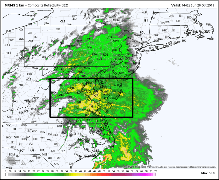
High pressure at the surface across New England will block the low from tracking north into that region, and as a result, model guidance has continuously shown that the heaviest rainfall will occur along I-95 north into Philadelphia, and east into Delaware and the Jersey shore.
There will be a tight gradient in rainfall totals as you progress west of the Poconos in Pennsylvania, and north of the New England coastline.
Rain will start to wrap up later this evening as the low gets kicked out to sea.

Meanwhile, my friends in Arkansas, Texas, Louisiana, Oklahoma, and Missouri need to be on the lookout for severe thunderstorms this evening, the NOAA SPC has put an Enhanced Risk out in the orange area circled.

At the base of the trough is our cold front, which will be the trigger for cloud development this afternoon and evening, before the hammer (rain) drops. We have quite a bit of surface convergence occurring as west, northwest winds push the front eastward into south winds from the Gulf of Mexico via a ridge.
These winds off of the Gulf are funneling in lots of moisture into a warm air mass, in which the water vapor will be forced to condensate out into clouds as the cold front forces the warm, moist air to rise, and cool the temperature to the dew point.
Tornadoes and damaging winds are very likely, so please tune into your local National Weather Service office for specific details.

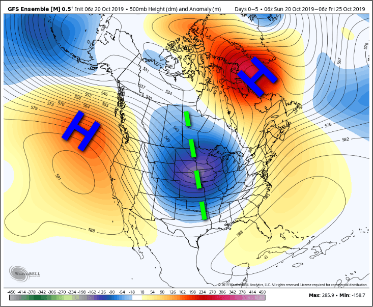
Both the GFS (shown below) and ECMWF ensembles are showing a quite amplified pattern across North America over the next five days; something we’ve already been seeing a lot this year.
A textbook omega blocking pattern is beginning to emerge as high pressure ridges build in over the North Pacific and Greenland while a corresponding trough settles in over the Central United States.
Another cold air outbreak has just begun and will last throughout much of the week ahead, though it’ll begin to subside by next weekend.

This weather pattern has been on recharge for the last few weeks and this looks to continue. With the MJO moving into Phase 2, the PNA soon going positive later this week, and the NAO tanking, I would not be surprised to see more sustained and prolonged cold over the Central and Eastern U.S. to close out October and to start November, and more coastal storm activity. For these longer-range tidbits, I’ll have much more information to share as more data becomes available; it’ll all be posted on my social media pages.
Thank you for reading! Please have a wonderful Sunday, stay safe, and God Bless!
Categories: Weather

Leave a comment