Author’s note: Thoughts on this page are mine and mine only. They may or may not reflect the thoughts or opinions of NOVA Weather Team’s. For decision making and preparations, PLEASE seek official NOAA National Hurricane Center (NHC) info.
Good afternoon everyone!
Hurricane Dorian is really crankin’ today. It remains a Category 4 thus far today, as maximum sustained winds have reached 149.6 miles per hour (130 knots) and the central minimum pressure has dropped like a brick to 945 millibars.
Dorian has run into a pocket of dry air on the northwest quadrant of the storm (see blue colors), which is killing off the thunderstorms there, however this dry air will not be plentiful enough to weaken the storm, unfortunately.

Over the past couple of days, Dorian has become much more mature in structure with the dry air mixing out, allowing the eye to become visible on satellite and an eyewall to form.
Due to the dry air, the “cloud mass” is now emphasized on the eastern side of the storm. However, it’s still moving west, northwest.

There appears to be some southwesterly flow off of Florida, Georgia, and the Carolinas while there is northeasterly flow coming from Bermuda. This is forming a clockwise rotation of air, denoting high pressure; the Bermuda High. This is pushing the storm west.

Dorian is expected to hit the Grand Bahama and Abaco Islands pretty hard tomorrow, that’s pretty much a solid forecast.
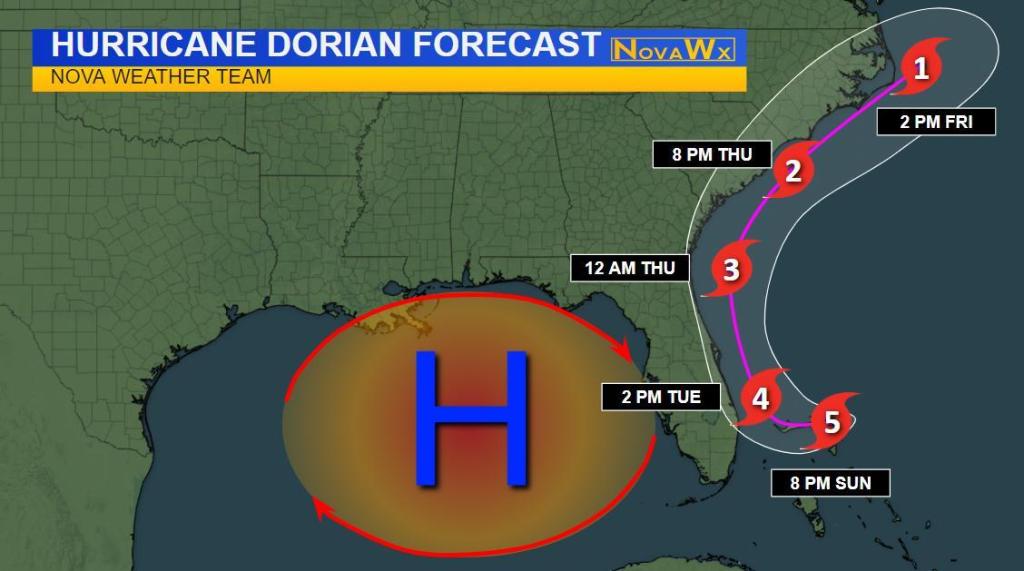
Here’s where things are a bit tricky with Dorian’s future after it hits the northern Bahamas.
A massive and unusually strong longwave trough, as shown on this jet stream-level image below, is coming through the eastern U.S.. This is why many locations in the Midwest, Mid-Atlantic, and New England have been having some VERY NICE and COOL mornings recently. You can easily see the trough axis tilting positively over the Corn Belt.
Meanwhile, a high pressure ridge is building in over the eastern Gulf of Mexico, and is bringing a northeast wind on Dorian, trying to force it to the southwest. This may force Dorian southwest very slightly.
However, southeast winds from the storm’s cyclonic (counterclockwise) flow will fight the northeast winds (where the north and south flow cancel out) and the westerly flows push the storm westward towards Florida.

However, the ridge over the Gulf will have opposing westerly flow (meaning winds are blowing west to east, hence westerly), preventing Dorian’s eye from moving over Florida, thus keeping it offshore.
This opposing flow causes Dorian to stall off of the southern coast of Florida, whereby an incredible amount of rain will subsequently fall over a relatively large, but isolated area.
As the Gulf ridge becomes suppressed to the south as the upper level trough rolls through, Dorian will split the elongated ridge into two separate ridges, thus creating a weak spot in the jet stream where Dorian can fill in and track north. This process will be unfolding Monday into early Wednesday.

After Wednesday, Dorian looks to trace the Atlantic seaboard up to the Outer Banks (first as a hurricane, then as a tropical storm, maybe even a depression) before the trough pushes it out to sea where it continues tracking northeast and falls apart as it reaches considerably cooler sea surface temperatures.

9/1 UPDATE:
Here is my updated forecast track; I have made a few adjustments.
Categories: Weather

Leave a comment