By Chris Martz | November 4, 2019
One of the first things I do while weather forecasting is study the 500 millibar height anomaly maps over the Northern Hemisphere, North America, or both.
The average air pressure at sea level is 1,000 millibars and decreases by half to 500 millibars around 18,000 feet in the atmosphere. 18,000 feet is the typical altitude at which you’ll find 500 millibars of air pressure aloft; or in other words, half of the atmosphere’s mass above a given point.
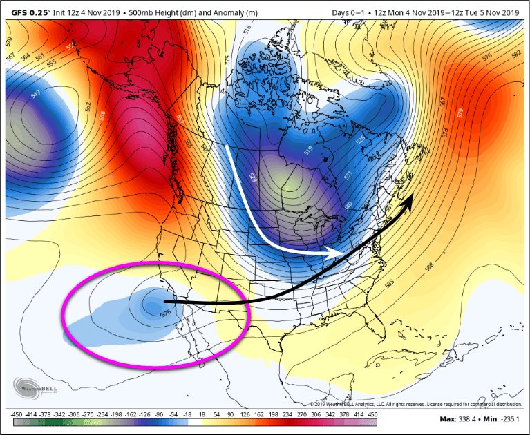
As shown in the two maps below of the 12z (12:00 z-time / 8:00 a.m. ET) runs of the GFS (American) (left) and ECMWF (European) (right) models, we see large contours of blue and purple, and orange and red.
Red and orange areas, often called ridges, signal areas of higher geopotential heights where the air is generally warm or hot. The blue and purple areas, known as troughs, signal low geopotential heights.
At 500 millibars, low geopotential heights signal areas where the 500 millibar level is lower in the atmosphere, which signals cool or very cold air near the surface. The reason for this is because cold air is denser than warm air, thus it is less buoyant.
As shown in the two maps below, the current upper air patterns show a large, deep trough over North America with the trough axis (denoted by a dotted green line) extending from Hudson bay down into the upper Mississippi Valley. On the other hand, a massive ridge has built in over the Gulf of Alaska, and Alaska itself with another, but less significant ridge over the North Atlantic Ocean.
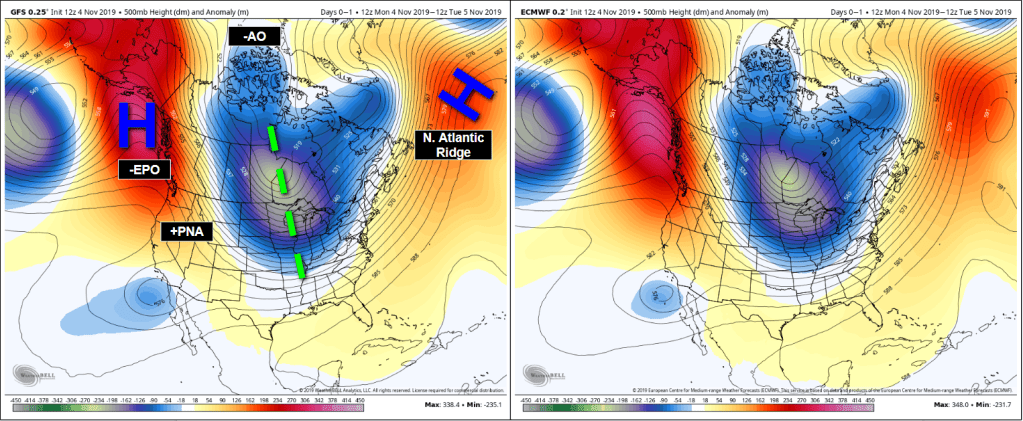
A key takeaway from the current upper air pattern is that because the North Atlantic Ridge hasn’t built in over Greenland (-NAO), the trough will be able to escape, causing more troughs to come in like waves rather than it being consistently in place.
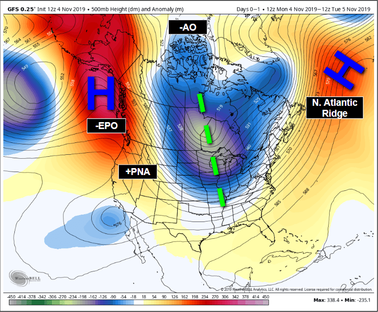
Because the base of the trough is situated over the Canadian Prairies and Upper Midwest of the United States, the cold air (both absolute and relative to average) back-builds west into the Dakotas, Manitoba, and Saskatchewan.

With the pattern in place, it’s safe to assume that we will expect a series of cold fronts that move from the Heartland through the Midwest and then to the East Coast. Indeed, this is exactly the case for the next several days, as a couple of cold fronts pass through reinforcing the chill in the air. Surface lows, of which the cold fronts are attached to, will bring some snow showers and lake-effect snow across the Upper Midwest and Great Lakes while providing scattered rain showers to the south; neither the rain or lake-effect, or snow showers will be significant.
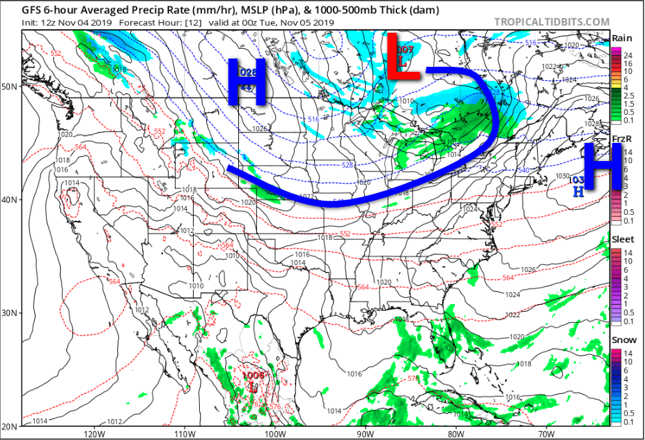
A second cold front is expected to arrive in the Midwest and Ohio Valley on Thursday evening with a very strong surface high (because cold air is dense) (and upper level trough of low pressure because of less overlying atmospheric mass at 500 millibars) behind it denoting a very dense, cold, Continental Polar (cP) air mass. At the same time, a shortwave trough in the upper levels (which you will see next) develops a surface low over Texas; the beginning of our next storm system.
A shortwave trough, which is currently situated just southwest of California, will (once again) spin up a surface low near Texas on Wednesday. Both the European (ECMWF) and American (GFS) models show this.
The shortwave trough, based on the last few runs of the GFS and ECMWF models, will likely interact with the northern branch of the jet stream phasing (coming together) with the upper level low (longwave trough) as it moves into the Midwest. What this will end up doing is pulling up into the Midwest, drag it through New England bringing some decent snowfall, while much of the Deep South and Mid-Atlantic get rain.
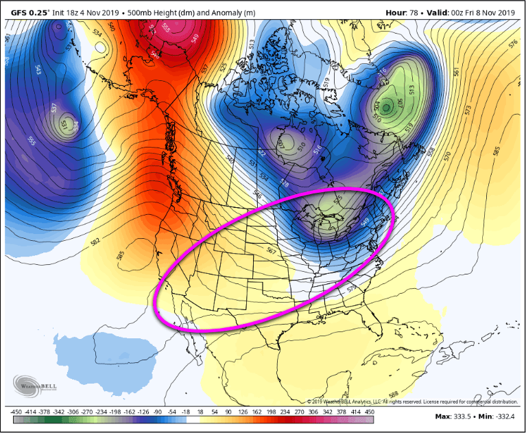
While earlier runs of the GFS and ECMWF had large discrepancy in output solutions, the two models have really come into pretty nice agreement over the course of today, November 4th. For the sake of time, I’m only going to show the European model solution.
For a better visualization of this at the surface, this first image for Wednesday evening shows our northern piece of energy (which may be an Alberta Clipper) and the developing low over Texas.
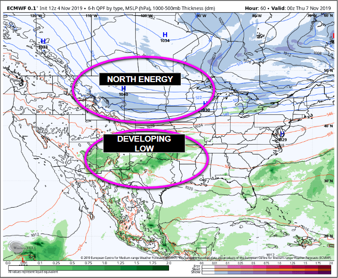
By 12z Thursday (8:00 a.m. ET), heavy rain will likely be falling from Texas and Oklahoma east towards the Tennessee Valley, while light snow begins to fall on the north side of the system where the cold air has changed the precipitation.
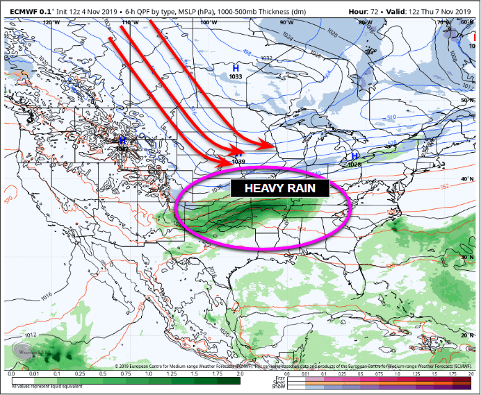
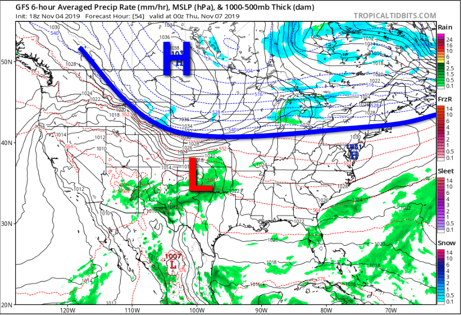
By Thursday afternoon and Thursday evening, rain will be falling as far east as the Ohio Valley, but once you get north of Interstate 70 from Kansas City to Chicago to Indianapolis to Cleveland, most of the precipitation falling will likely be snow, sleet or freezing rain (likely snow for most, but I can’t nail the details until we get closer).

By late Thursday evening or early Friday morning, the progressive (fast) flow of the jet stream will have pushed this system along; all snow is done for Indiana and Illinois. However, the rain has started to move into the Southeast, while snowfall rates have increased from the Ohio Valley to Pennsylvania and New York state. If the European, and even the GFS model solutions are correct at this point in the game, we could be looking at sustained snowfall rates of 1 to 3 inches per hour for about 3 to 5 hours from Northwestern Pennsylvania into Southern and Central New York, Western Massachusetts, southern Vermont, New Hampshire, and Maine before the low moves out and cold air progresses in.

Where exactly the rain/snow line sets up at this point is anyone’s guess, but I think the Poconos in Pennsylvania, southwest towards the Allegheny Front of West Virginia will be the general area. As far as snow totals go, I really wouldn’t expect a whole lot for much of the Ohio Valley and Midwest (maybe 1-3 inches), but significantly more will likely fall across interior Pennsylvania, Southern New York, Western Massachusetts, Vermont, New Hampshire, and Maine.
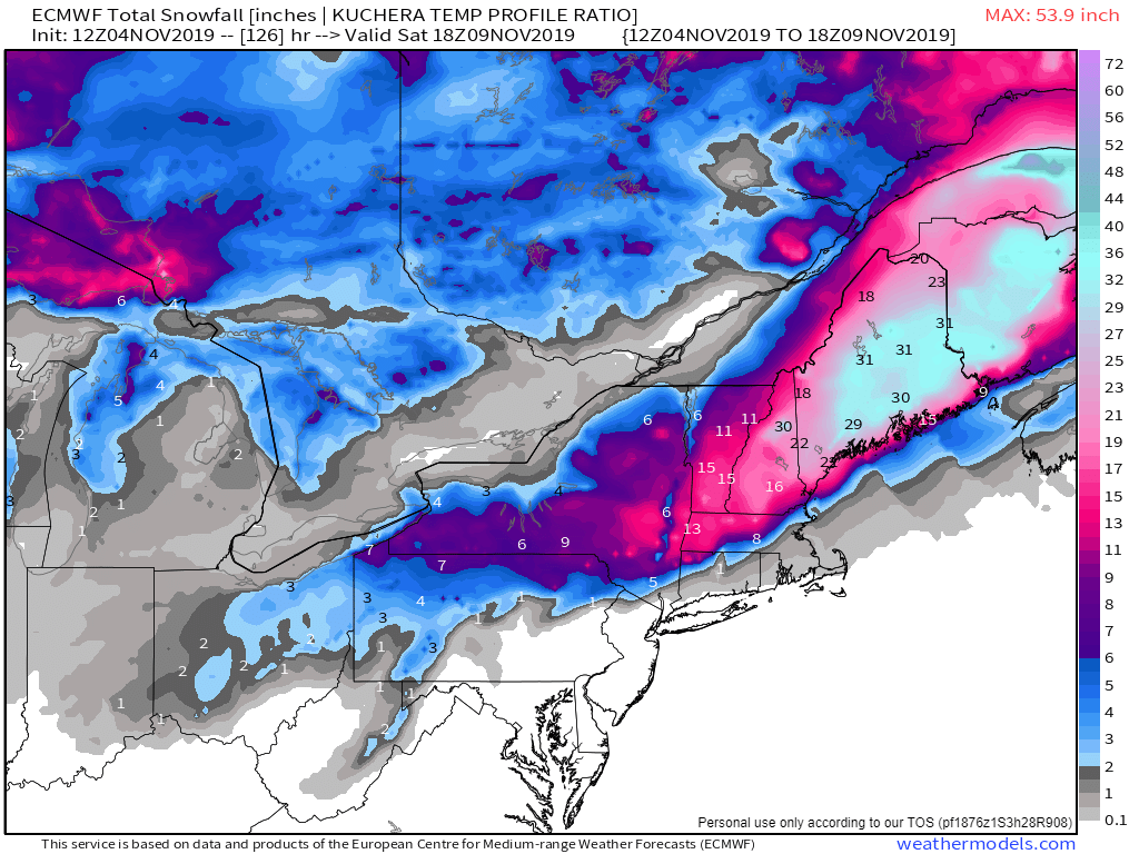
Just to give you an idea of what the models are simulating for the weekend, here is what the ECMWF temperature profile (NOT 10:1 liquid/snow ratios) Kuchera Snowfall map is showing. I like this solution for the most part, but I am almost certain the 15-30+ inches shown across Eastern New York, Vermont, New Hampshire, Massachusetts, and Maine is wishful thinking on the model’s part.
The 18z GFS Kuchera map (not the 10:1 ratio map) shows a similar, yet less aggressive solution, which I also like.

I will make my official snowfall map on Wednesday evening, it will be posted here with an UPDATE tag as well as on my Twitter, Facebook, and Instagram pages.
Categories: Weather

Leave a comment