By Chris Martz
Follow @ChrisMartzWX

We’re on the verge of wrapping up the month of April as we are full steam ahead toward the final month of meteorological spring, but winter is still trying to keep its grip on the Midwest.
A storm system dubbed Winter Storm Xyler – by The Weather Channel – has made its way across the Dakotas and is now roaring towards the Great Lakes, Midwest, and parts of New England.
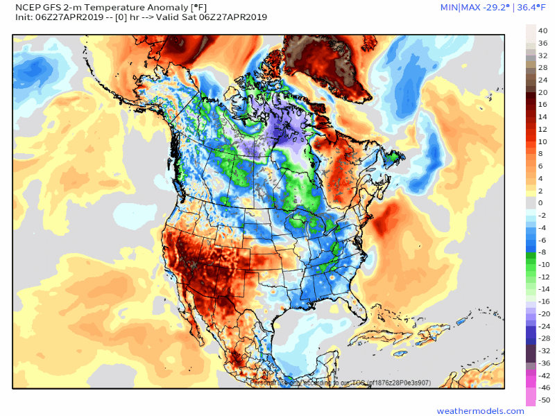
Behind the storm will be well below average temperatures that will stretch from the Rocky Mountains all the way to the east coast (Figure 1).¹
For some communities, this could be one of the heaviest, if not the all time heaviest, late-season snowfalls on record.
Areas like eastern South Dakota and southwestern Minnesota have already been impacted with moderate snowfall; all surfaces like roads, sidewalks, and grass have been covered.² The National Weather Service office in Sioux Falls, SD officially picked up 1.5 inches of snow while other areas reported as much as three inches.²
At 9 am the snow had changed to light rain at the Sioux Falls Airport. Another 0.1 inch of snowfall brought the total up to 1.5 inch.
— NWS Sioux Falls (@NWSSiouxFalls) April 27, 2019
Cities like Milwaukee, WI could see one of their biggest late-season snowfalls since 1990, while areas near Grand Rapids, MI could see their biggest late-season snowfall since 1963!²
Meanwhile, Chicago stands out above all of these cities because they may see their latest 2+ inch snow event on record.
Chicago will likely break the record snowfall for the date, which currently sits at 0.2 in. from 1950. Models are showing 2 to 4 inches of snowfall for the city. If at least 2 inches of snow falls, this will go down as the latest 2+ inch snow event on record for the city. pic.twitter.com/5uwo8Q08DU
— Chris Martz Weather🌪️ (@ChrisMartzWX) April 27, 2019
That’s right, the “windy city” is likely to see their latest “decent” snowfall ever recorded.
Model output statistics (MOS) show that anywhere from two to four inches of snow is on the order for the city. High-resolution guidance like the North American (NAM) Model (Figure 2) and the High Resolution Rapid Refresh (HRRR) Model (Figure 3) show Chicagoland receiving about three inches of snow, give or take half and inch.³ ⁴


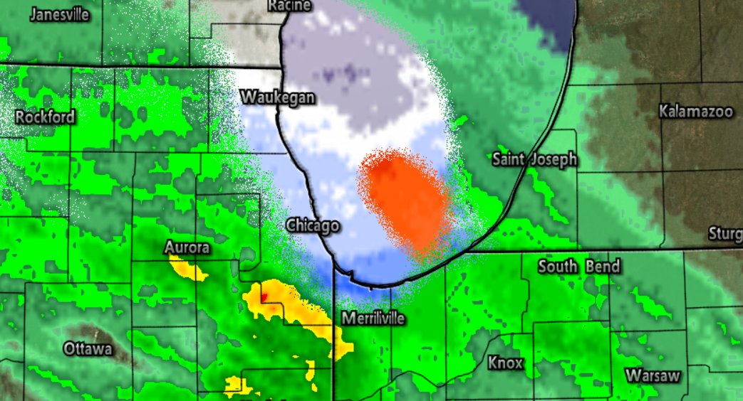
The rain has already transitioned over to snow (Figure 4) for many areas around Chicago and if rates are steady enough, they may very well pick up the same amounts shown on MOS data. The biggest roadblock which may prevent record snowfall for the area is the high April sun angle, which works against snowfall rates.
However, if Chicago does receive at least two inches of snow by the time this system is all wrapped up, then it will go into the record books for the latest 2-inch snowfall in the city’s history!
Looking back at historical records, I was able to find that Chicago’s latest 1-inch snow event occurred on May 1, 1940, when 1.6 inches of snow fell.⁵

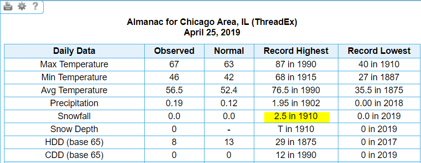
Chicago’s latest 2-inch snow event occurred on April 25, 1910, when 2.5 inches fell on the city.⁵
Furthermore, Chicago’s latest 3-inch snow event occurred on April 23, 1967, when 3.1 inches of snow fell, oddly enough the same year the city recorded their largest snowstorm of 23 inches on January 26-27.⁵ ⁶

Regardless of how much snow Chicago receives over the next 24 hours, this will NOT go in the books as the latest 1-inch snowfall, but it has a very good shot of being the latest 2-inch or 3-inch event.
2019 has brought nothing but weather records to Chicago; back in January they had one of their coldest Arctic outbreaks on record, while they also had their second longest stretch of temperatures below 54 degrees.
Why not add another record to the books?
REFERENCES
[1] Maue, Ryan, Jack Sillin, and Joerg Kachelmann. “Weathermodels.com.” Weathermodels.com. Accessed April 27, 2019. https://weathermodels.com/.
[2] Lam, Linda. “What Spring? Winter Storm Xyler Will Spread Snow and Colder Temperatures From the Dakotas to the Great Lakes.” The Weather Channel. April 27, 2019. Accessed April 27, 2019. https://weather.com/storms/winter/news/2019-04-26-winter-storm-xyler-forecast-midwest-great-lakes-northeast.
[3] Cowan, Levi. “NAM 3km Model.” Tropical Tidbits. Accessed April 27, 2019. https://www.tropicaltidbits.com/analysis/models/?model=nam3km®ion=ncus&pkg=asnow&runtime=2019042712&fh=18.
[4] Cowan, Levi. “HRRR Model.” Tropical Tidbits. Accessed April 27, 2019. https://www.tropicaltidbits.com/analysis/models/?model=hrrr®ion=ncus&pkg=asnow&runtime=2019042715&fh=15.
[5] “xmACIS2.” xmACIS2. Accessed April 27, 2019. http://xmacis.rcc-acis.org/.
[6] Tag, Danny. “Chicago’s Top 5 Biggest Snowstorms.” ABC7 Chicago. January 18, 2019. Accessed April 27, 2019. https://abc7chicago.com/weather/chicagos-top-5-biggest-snowstorms/5004898/.
Categories: Weather

Leave a comment